We provide AERMET and AERMOD Model-ready Meteorological and Terrain datasets for any specific location.
The data is pre-processed appropriately to the standards of U.S. EPA.
Met Data - Same Day Delivery
Within 24-hour, we deliver model-ready files for any location inside INDIA for direct AERMOD or AERMET or CALPUFF model run.
Online tool for AERMOD Model Users. (beta version)
Last modified 12d 4h ago
An online tool that helps you to generate your own hourly surface meteorological data files, which can be used to run AERMET.
This tool converts hourly surface meteorological data which is contained in an Excel file to the SAMSON file format.
Use of SAMSON file format is quite common among AERMOD users, because, AERMET can extract hourly surface weather observations from SAMSON file. AERMET can not extract meteoroglogical data from Excel file.
AERMET is preprocessor for organizing available meteorological data into a format suitable for use by the AERMOD air dispersion model.
SAMSON (Solar And Meteorological Surface Observation Network) is one of the several standard format used storage and distribution meteorological data.
AERMET is preprocessor for organizing available meteorological data into a format suitable for use by the AERMOD air dispersion model.
Instructions
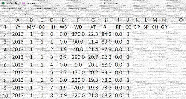
File Preparation
The excel file must have the Parameter Identifier in the first row of the respective data column. The highlighted parameters are mandatory.
YY
Year
YYYY (as 2022)
MM
Month
MM (as 01-12)
DD
Date
DD (as 01-31)
HH
Hour
HH (as 00-23)
WS
Wind Speed
m/s
WD
Wind Direction
from Noth
AT
Ambient Temperature
oC
RH
Relative Humidity
%
RF
Rainfall
mm
CC
Cloud Cover
tenth
DP
Dewpoint
oC
SP
Station Pressure
mb
CH
Ceiling Height
m
GR
New Global Radiation
wh/m2
Important Note
For now this application does not convert units therefore, the unit of the data in the file must be as indicated in the table.
Use negative (-) sign with degree (latitude/longitude) to indicate WEST or SOUTH
Missing Data Processing:
The application may estimate Global Radiation , Ceiling Height, Dew Point, Relative Humidity if the primary parameteres are availble.
To enable this option tick the check box "Estimate Missing Data".
AERMOD Cloud®
A truly integrated US EPA AERMOD air dispersion modelling system - AERMET, AERMAP and BPIPRM within ONE Interface.
We use necessary cookies to make our site work. We'd also like to set analytics cookies that help us make improvements by measuring how you use the site. These will be set only if you accept.
For more detailed information about the cookies we use, see our Privacy Page.